
Navionics Platinum+ premium marine charts expand & enhance relief shading coverage around the world
by Garmin 26 May 2023 08:36 PDT
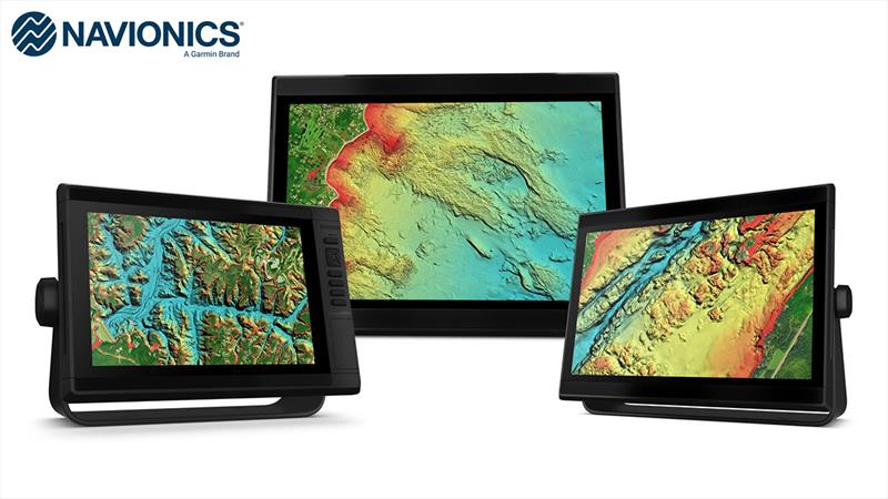
New Relief Shading for Navionics © Garmin
Garmin (NYSE: GRMN), the world's most innovative and recognised marine electronics manufacturer, today announced expanded and enhanced high-resolution relief shading coverage to Navionics® Platinum+™ premium marine charts for compatible chartplotters.
The update from Navionics provides 120% more relief shading coverage for many new coastal and inland waters than previous charts. Combining colour and shadow, relief shading gives boaters, anglers and divers an easy-to-interpret, clearer view of what's below the surface than contour lines alone—and is now available on more than 40,000 additional lakes.
"Our team is continuously working to update our robust relief shading to provide combined inland and coastal content for our Navionics Platinum+ charts, enhancing mariners' experience so they can focus on exploring the waters they enjoy most. Additionally, mariners can continue to utilise the same quality content and premium features, such as high-resolution relief shading chart overlays, to support an enhanced navigation experience—whether on the lake or off the coast." — Dan Bartel, Garmin Vice President of Global Consumer Sales
Platinum+ provides boaters, anglers and divers access to an exclusive relief shading overlay with availability in lakes and rivers in the U.S., Canada, Europe, Africa, Australia and New Zealand1. Platinum+ offers a variety of features — such as daily chart updates, chart overlays and advanced routing technology — that are designed to smoothly guide boaters on the water, or quickly lead anglers to where the fish may be hiding. The expanded relief shading, which was recently made available in the Navionics Boating smart device app, reveals the shape of a lake, river and ocean seabeds in a vibrant new colour palette that provides a better understanding of depth changes at a glance and makes it easier to identify sharp ledges, points or other changes in bottom structure.
A one-year subscription is included with the purchase of a Navionics Platinum+ chart card, offering a quick and easy way to access unlimited daily chart updates via the Navionics Chart Installer, or using the Plotter Sync feature in the Boating app. Charts also feature up to 1-foot depth contours, community edits, depth shading and shallow water shading options for insight into inland and coastal waters.
An even clearer picture
Platinum+ premium charts' new colour palette and image quality deliver a clear image of bottom detail that uncovers promising fishing spots, navigation channels and more. Multiple shading options aid in shallow water navigation, making it easier to choose depth ranges when searching for the best fishing spots. Additionally, numerous wrecks were targeted for enhancement to assist anglers and divers identify more precise spot-on-the-spot locations.
Daily map updates
With up to 5,000 updates to map content every day, Platinum+ mapping offers fresh insights about covered bodies of water for enhanced situational awareness and peace of mind while navigating. The mapping is revised daily from public and private sources which include proprietary surveys and Notice to Mariners to give mariners the most up-to-date information available from Navionics. With mapping coverage of coastal and inland waters worldwide, daily updates allow for immediate access to new content and chart data as it is updated. Once the year-long subscription is activated, customers can access unlimited daily map updates using the Navionics chart installer.
Platinum+ premium charts are available now starting at £239.99. The maps come on a microSD/SD card for simplified installation compatible with third-party chartplotters. To learn more, visit www.navionics.com.
1Level of detail will vary based on the location and sources used.